Taeha Coastal Trail and Daepunggam Cliff (태하 해안산책로 및 대풍감 (울릉도, 독도 국가지질공원))
Taeha-ri, Seo-myeon, Ulleung-gun, Gyeongsangbuk-do
Quick answer
Taeha Coastal Trail and Daepunggam Cliff (태하 해안산책로 및 대풍감 (울릉도, 독도 국가지질공원)) is a attraction in Taeha-ri, Seo-myeon,. Taeha Coastal Trail can be reached by crossing the pedastrian bridge next to Hwangtogul Cave. Use the address, map link, visitor details, and official links below before deciding whether it fits your Korea itinerary.
About Taeha Coastal Trail and Daepunggam Cliff (태하 해안산책로 및 대풍감 (울릉도, 독도 국가지질공원))
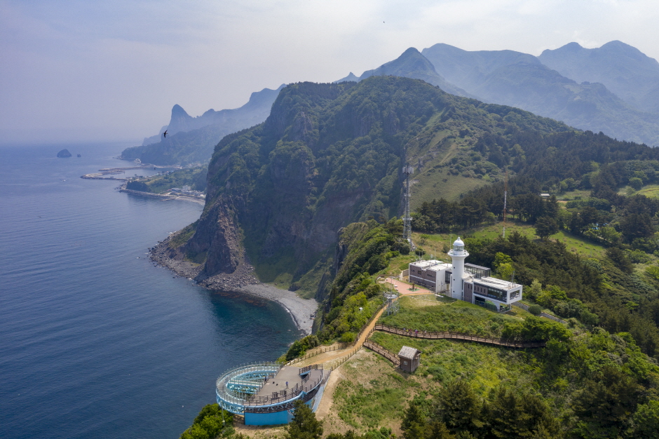
Taeha Coastal Trail can be reached by crossing the pedastrian bridge next to Hwangtogul Cave. While crossing the bridge, visitors can enjoy murals of Taeha Village and a photo zone. Taeha Coastal Trail is made up of trachyte and agglomerate rocks, and boasts beautiful coastal scenery due to the unique topography eroded by the wind. It is also where one can observe tafoni, a honeycomb-shaped rocks that weathered by the reaction of salts contained in sea breezes. By taking the Taeha Hyangmok Tour Monorail for about 6 minutes and walking along the trail for about 20 minutes, visitors will reach Ulleungdo Lighthouse (Taeha Lighthouse) and the Hyangmok Geo Skywalk. Junipers in Daepunggam Cliff grew in weathered soil formed in the cracks of columnar joints, creating a unique ecological environment isolated from inland areas for a very long time. Due to its significance, Junipers were designated as natural monuments.
- Type
- Attraction
- Address
- Taeha-ri, Seo-myeon, Ulleung-gun, Gyeongsangbuk-do
- Postal code
- 40200
- Phone
- +82-54-791-2191
- Opening hours
- Open 24 hr
- Fees
- Confirm before visiting
- Parking
- Not available
- Updated
- 2024-03-29
- Data last synced
- 2026-06-25
Best for
- First-time visitors comparing Korea places by area.
- Travelers who need official address and map context.
- Visitors building a day route with nearby attractions.
Visitor tips
- 1
Check current opening hours, tickets, reservations, and holiday notices before visiting Taeha Coastal Trail and Daepunggam Cliff (태하 해안산책로 및 대풍감 (울릉도, 독도 국가지질공원)).
- 2
Save the Korean address and nearest station or landmark before leaving your hotel.
- 3
Prepare a taxi destination card if you are arriving late, carrying luggage, or traveling with family.
Directions and official information
Open this location in Google Maps. Confirm official access details before visiting.
External sites open in a new tab.
Address tools
Use these tools when a taxi driver, hotel, shopping form, or delivery service needs a Korean address, postal code, phone number, or destination card.
Taeha Coastal Trail and Daepunggam Cliff (태하 해안산책로 및 대풍감 (울릉도, 독도 국가지질공원)) FAQ
Where is Taeha Coastal Trail and Daepunggam Cliff (태하 해안산책로 및 대풍감 (울릉도, 독도 국가지질공원)) located?
Taeha-ri, Seo-myeon, Ulleung-gun, Gyeongsangbuk-do
How can I check current opening information?
Use the official tourism or place website before visiting because operating information can change.
How do I find nearby places?
Return to the Korea travel list to explore more official attractions and destinations.
Can I rely on this page as official information?
No. Use ComeKR as practical travel guidance and confirm opening hours, prices, reservations, transport details, and notices with official or provider sources before visiting.