TRAVEL IN KOREA
Korea Places to Visit
Find attractions, culture, festivals, stays, restaurants, shopping and travel courses for a clear Korea trip plan.
Data last synced: 2026-06-25. Some details may change. Please confirm official information before visiting.
Seongmodo Shrubby Sea-blite Habitat (석모도 칠면초 군락지)
29-3 Maeeum-ri, Samsan-myeon, Ganghwa-gun, Incheon
Seongmodo Shrubby Sea-blite Habitat is a habitat where a colony of shrubby sea-blite flourishes on tidal flats. Situated on the route to Minmeoru Beach, accessible via the Seongmodaegyo Bridge, this area is known for the robust growth of seepweed, which forms colonies in tidal flats or areas with high salinity. From September to mid-October, the landscape transforms with vibrant reddish-pink flowers, often referred to as the "fall foliage of the sea."
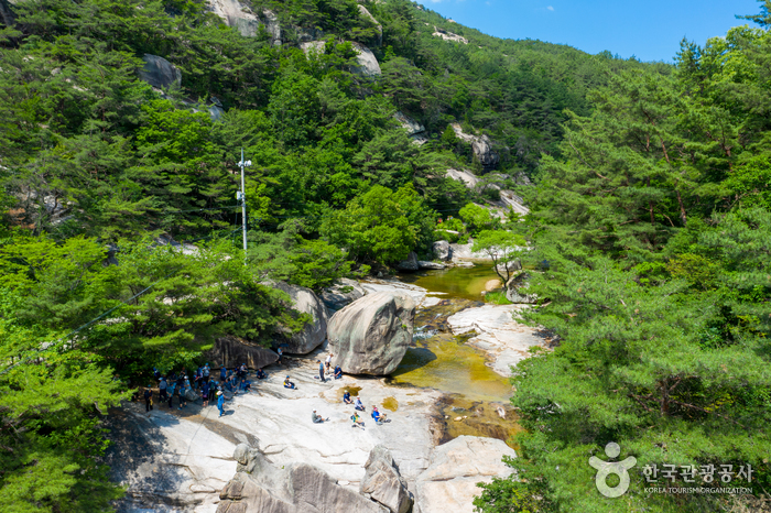
![Seongnyugul Cave [National Geopark] (성류굴 (경북 동해안 국가지질공원))](http://tong.visitkorea.or.kr/cms/resource/42/2613142_image2_1.jpg)
Seongnyugul Cave [National Geopark] (성류굴 (경북 동해안 국가지질공원))
221 Seongnyugul-ro, Geunnam-myeon, Uljin-gun, Gyeongsangbuk-do
Seongnyugul Cave, a Natural Monument of Korea, is a limestone cave with a general northeast-southwest orientation. It has a total length of about 870 meters, of which only a strip of 270 meters is open to the public. Inside the cave are a variety of cave formations, including stalactites, stalagmites, columns, and cave pearls, which are commonly found in limestone caves. Unlike other limestone caves in Korea, Seongnyugul Cave has twisted columns and submerged stalagmites. Twisted columns are often broken in the middle due to earthquakes that occurred after the columns were formed. Submerged stalagmites are notable because stalagmites usually do not grow under water as they are made from droplets that fall from the ceiling. As such, stalagmites found underwater were submerged after they were created, indicating that they were created during the Ice Age, when the East Sea was lower than the present level. (Credit: Gyeongbuk Donghaean Geopark)
Seongsan Ilchulbong Tuff Cone [UNESCO World Heritage] (성산일출봉 [유네스코 세계문화유산])
284-12 Ilchul-ro, Seogwipo-si, Jeju-do
Seongsan Ilchulbong Tuff Cone rose 180 meters above sea level due to a magma flow under the sea over 5,000 years ago. It was originally a separate island, but a build-up of sand and soil has connected it to the main island. A large crater, formed by the hot lava mixing with cold ocean water, is located at the top of Seongsan Ilchulbong Tuff Cone. The crater is about 600 meters in diameter and 90 meters deep. It has been featured in films, and was originally used for agriculture, but has now been given over to a field of silver grass. From the summit, visitors can see Udo Island, as well as take in the magnificent sunrise. The tuff cone area was designated as a natural reserve on July 19, 2000.
Seongsu-dong Cafe Street (성수동 카페거리)
Seongsu-dong, Seongdong-gu, Seoul
Yeonmujang-gil in Seongsu-dong, known for old factories and a shoe workshop street, has been reborn as a place of trendy cafes and culture. The energy of car repair shops, printing factories, and handmade shoes street still exist today but, as global restaurant brands, select shops, and cafes have set up amidst busily operating factories, an atmosphere unique to Seongsu-dong has been created. "Daerim Warehouse" led to the change in the Seongsu-dong streets and can be said to be the originator of all warehouse-style cafes that are popular throughout Cafe Street today. The red-brick structure, antique signboards, and a vast indoor space of an old warehouse have been maintained and, with the addition of a sensuous interior design, it has become a space suitable for fashion shows and exhibits, thus showing new potential for old Seongsu-dong architecture. Every day, new cafes, bakeries, restaurants, and cultural complexes open their doors and are busy welcoming visitors.

Seongsu-dong Handmade Shoes Street (성수동 수제화거리)
15, Yeonmujang 7-gil, Seongdong-gu, Seoul
Handmade shoe manufacturers began to gather in the 1970s to form a street and make history. Today, there are some 350 handmade shoe manufacturers, 100 intermediate processing and raw materials companies, and new cafes with unique vibes opening up one after another. Thanks to its vintage appeal, many people visit on dates and to take cool photos.
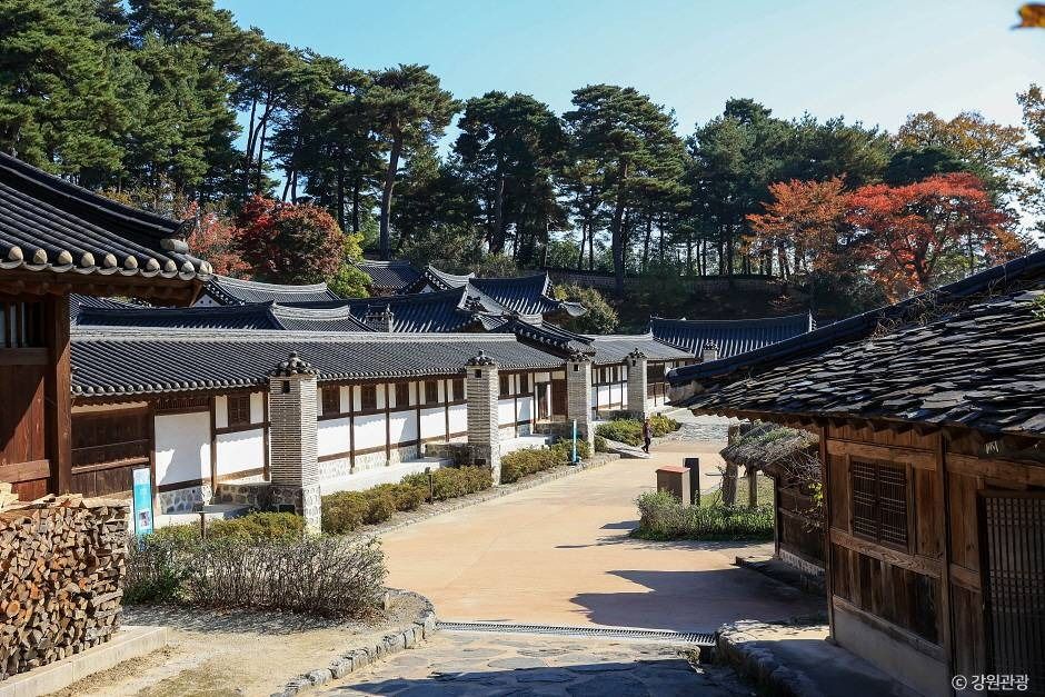
Seongyojang House (강릉 선교장)
63, Unjeong-gil, Gangneung-si, Gangwon-do
Seongyojang House is the former upper class residence of Lee Nae-beon (1703-1781) and his family in Gangneung, Gangwon State. It was designated as a National Folklore Cultural Heritage in 1967. The one-syllable word "Seon" in Seongyojang means boat. Gyeongpoho Lake was right in front of Seongyojang House at the time it was built, thus making is accessible by boat. Seongyojang House has all the features of a typical upper class residence during the Joseon period. The complex even has a large pond with a pavilion named Hwallaejeong Pavilion. While the building still blends beautifully with the surrounding nature, Seongyojang House has been well-preserved and is considered a valuable resource in the historical research of living conditions of upper class households during the Joseon dynasty.
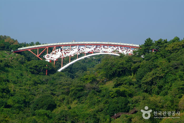
Seonimgyo Bridge (선임교)
27 Saekdal-ro 189beon-gil, Seogwipo-si, Jeju-do
Seonimgyo Bridge is a 130-meter-long arched iron bridge connecting Cheonjeyeonpokpo Falls to the Jungmun Tourist Complex. Legend says that the Seven Fairies descended from the sky and landed on the bridge, hence earning the name "Seonimgyo." The bridge is also known as the Fairy Bridge or the Cloud Bridge, and there are statues of the Seven Fairies on both sides of the bridge. Thirty-four stone lanterns between the 100 railings make it a beautiful night view spot.
Seonnyeobawi Beach (선녀바위해수욕장)
60 Seonnyeobawi-ro, Jung-gu, Incheon
Seonnyeobawi Beach is renowned for its stunning rock formations, especially the Seonnyeobawi Rock, attracting numerous visitors eager to witness the rock's striking silhouette against the sunset. Behind the Seonnyeobawi Rock, visitors can observe small, aged fishing boats and fishers at work on the quaint quay. In comparison to the more popular Eurwangni Beach nearby, Seonnyeobawi Beach usually experiences fewer crowds, making it a perfect spot for those seeking a peaceful retreat.
![Seonunsan Mountain [National Geopark] (선운산 (전북 서해안 국가지질공원))](http://tong.visitkorea.or.kr/cms/resource/64/2678864_image2_1.jpg)
Seonunsan Mountain [National Geopark] (선운산 (전북 서해안 국가지질공원))
158-6, Seonunsa-ro, Gochang-gun, Jeonbuk-do
Seonunsan Mountain is famous for its sunrise views at Nakjodae Overlook and Cheonmabong Peak. The mountain is mostly comprised of hard volcanic rocks, creating a landscape of sharp cliffs softened by the forest vegetation.

Seonyudo Beach (선유도해수욕장)
Okdo-myeon, Gunsan-si, Jeonbuk-do
Seonyudo Beach, is a natural coastal sand dune beach with a vast white sand area as transparent and beautiful as glass beads, which is why it is also known as Myeongsasimni Beach. At Seonyudo Beach, the depth of the water is only waist-high even at 100 meters into the sea, and there are no high waves so even children can play in the water safely.
Seonyudo Island (선유도)
34-22, Seonyunam-gil, Gunsan-si, Jeonbuk-do
Seonyudo Island, one of the most popular tourist destinations on the west coast during the summer, lies in the heart of the Gogunsan Archipelago. The island has an area of 2.12 ㎢, which is only about 1/4 of Yeouido in Seoul. The island's coastal shore is around 12.8 kilometers long and the highest point is Namaksan Mountain, which reaches about 155.6 meters in altitude. Seonyudo is the central point of Gogunsan Archipelago and has even served as the headquarters for the naval army during the Joseon dynasty. It played a vital role during the Imjin War as Admiral Yi spent days on the islands to prepare for the next battle after his victory in the Battle of Myeongnyang. Visitors can enjoy the island in three ways. First is to look around the neighboring islands. Seonyudo, Munyeodo, Jangjado, and Daejangdo islands are all connected by a bridge, allowing one to move between the islands on foot or a bicycle. Other ways to enjoy the island is to take a walk along the Myeongsa-simni Shore, one of the Eight Scenes of Seonyudo, and to try the clam collecting program at a mudflat.
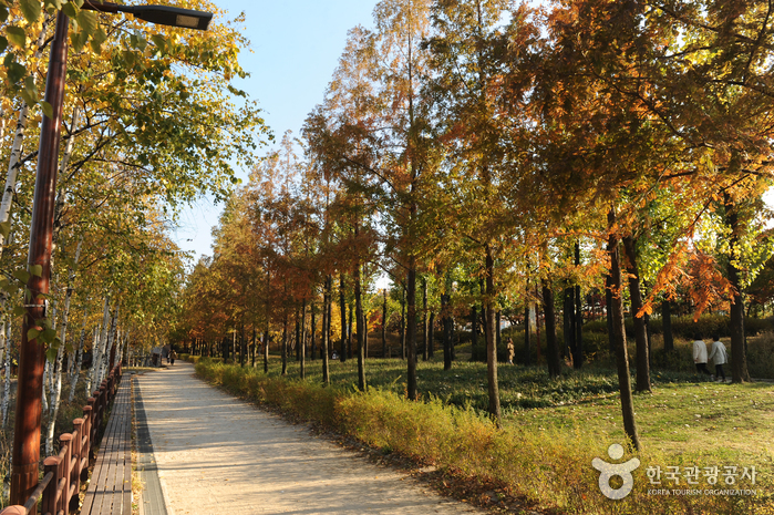
Seonyudo Park (선유도공원)
343 Seonyu-ro, Yeongdeungpo-gu, Seoul
Seonyudo Park is Korea's first water-themed ecological park. The park was renewed from an old water treatment plant. Visitors can observe a water purification system, an aquatic plant garden, and an ecological forest, as well as exhibitions and other interesting facilities. The park also hosts diverse hands-on programs and exhibitions.
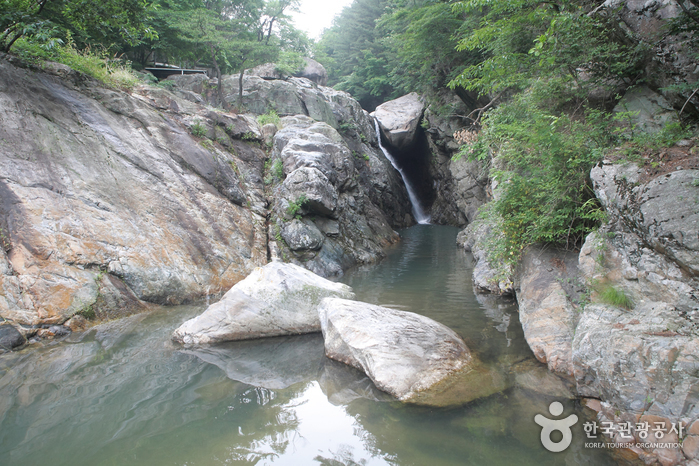
Seonyudonggyegok Valley (Sancheong Section) (선유동계곡(산청))
Suwol-ro, Sancheon-gun, Gyeongsangnam-do
Seonyudong means the place where fairies come down from heaven to play. It has been said that fairies would often come down to the valley to make liquor and store them in flagons. There are some leftover depressions in the boulders which demonstrate there may be some truth to the legend. Near Seonyudonggyegok Valley, they say that the bamboos and pine trees stay green all year long and wood nymphs fly down to play with each other under the Suwolpokpo Falls in Suwol Village.
Seonyudonggyegok Valley (선유구곡(선유동계곡))
179, Seonyudong-gil, Goesan-gun, Chungcheongbuk-do
Seonyudonggyegok Valley is located in Goesan-gun, Chungcheongbuk-do Province. Including Seonyudongmun, the playground for the mountain gods, a total of nine valleys form the area: Gyeongcheonbyeok, Haksoam, Yeondallo, Waryongpok, Nangadae, Gigugam, Guam, and Eunseonam. Seonnyudonggyegok Valley is famous for the legend that mountain gods came to savor fresh mountain spring water. A renowned geographical account, Taekriji, published in 1751, stated that Seonyudonggyegok Valley boasted some of the best scenery. One of the most eminent Confucian scholars of the Joseon dynasty, Lee Hwang spent nine months in this beautiful valley. He gave names to all his favorite places, which still remain to this day.
Seopirang Park (서피랑공원)
22 Chungnyeol-ro, Tongyeong-si, Gyeongsangnam-do
Seopirang Park, located on Seopirang Hill in Tongyeong, showcases the region’s unique charm and historical significance. The park features walking trails, 99 stairs, a music garden, and piano stairs, with vibrant murals along the uphill path that make the climb enjoyable. From sunset to midnight, the park is beautifully illuminated, creating a magical atmosphere. At its summit, Seoporu, visitors are treated to stunning panoramic views of Tongyeong Bay and the city.
Seopjikoji (섭지코지)
107 Seopjikoji-ro, Seogwipo-si, Jeju-do
Seopjikoji gets its name from its shape, jutting out to sea, with 'koji' being the Jeju dialect for a cape. Located just south of Seongsan Ilchulbong Tuff Cone, the cape is a popular tourist attraction. The tuff cone along with a beautiful vista of the ocean and fields of canola flowers can easily be seen from the peak of Seopjikoji. On top of the hill stands a beacon fire station, reaching 4 meters in height with a diameter of 9 meters, built using volcanic rocks. Behind the beacon fire station is Bulgeunoreum Volcanic Cone, vibrant with red soil. The white lighthouse atop the cone stands out in contrast. Seopjikoji has been used as a filming site for many Korean movies and dramas.
Plan your Korea trip
Korea travel FAQ
How do I use the travel search?
Enter a place or interest, then narrow the results by region, category or sort order.
Will my filters stay selected on the next page?
Yes. Your search and filter choices stay in the page URL while you move through the results.
Can I find directions to each place?
Place pages include an external Google Maps search when coordinates or an address are available.
Source: Korea Tourism Organization, official website (https://knto.or.kr).